Geo-enabled digital microplanning: revolutionizing immunization in Bangladesh
Since launching the Expanded Programme on Immunization (EPI) in 1979, Bangladesh has made remarkable progress- from just 2% full immunization coverage in its early years to over 60% by 1990. To reach every child, the government adopted the Reach Every District (RED) strategy in 2003, evolving to Reach Every Community (REC) in 2017. Yet, challenges in accurate mapping and identifying underserved populations persisted.
To address this, WHO in coordination with National EPI and MIS supported introduction of Geo-Enabled Digital Microplanning using Geographic Information Systems (GIS). Despite existing digital data entry, paper-based, hand-drawn maps limited the accuracy of microplanning. GIS integration is transforming this approach.
With ArcGIS as the chosen platform, this initiative enhances:
• Mapping of vaccination sites and catchment areas
• Identification of un- or under-vaccinated populations
• Travel distance analysis for remote communities
• Monitoring of VPD outbreaks, AEFI and service performance
• Health Worker alerts and supervision tracking
• Data visualization through interactive dashboards
Following a successful pilot in 2023 across four regions—including Rajshahi and Mymensingh City Corporations—GIS-based microplanning is now scaling up. WHO, in collaboration with the Ministry of Health & Family Welfare, UNICEF, PATH, and HiSP, is supporting the rollout across 29 districts and 4 city corporations. A live dashboard on the DGHS portal now provides real-time data to policymakers and stakeholders.
Across Bangladesh, EPI data is initially recorded on paper during vaccination sessions and subsequently used for data entry, surveillance, stock management, and program monitoring. At the Union, Upazila, and City Corporation levels, this information is digitized into a centralized platform to support decision-making and program management.
Challenges:
• Data Collection and Microplanning: Data collected on paper maps during vaccination sessions sometimes lacked precision, leading to challenges in identifying human settlements and populations needing vaccination. This could result in unserved areas.
• Identifying accurate catchment area.
• Current System: Although data is entered digitally, the reliance on hand-drawn maps for microplanning compromises the accuracy of identifying target areas.
The World Health Organization spearheaded the integration of Geographic Information Systems (GIS) to strengthen the Expanded Program on Immunization (EPI) in Bangladesh. This initiative aims to:
• Determine groups and geographic areas that require prioritized access to vaccines;
• Analyze vaccination coverage levels and evaluate access to vaccination facilities, including defining catchment areas;
• Calculate distances and estimated travel times for populations—especially in hard-to-reach areas—to reach health facilities;
• Detect communities with unvaccinated or under-vaccinated children missed during microplanning and routine immunization services;
• Enhance the registration systems for children and pregnant mothers to improve tracking and service delivery;
• Monitor and alert health workers about reported VPD cases, notified diseases, and serious adverse events following immunization (AEFI);
• Track supervision visits, monitoring activities, and overall performance of the EPI program;
• Create detailed maps of vaccination sites, VPD surveillance points, and AEFI monitoring locations;
• Train health personnel in using ArcGIS and develop a robust platform for monitoring and mapping VPDs, AEFI, routine immunization, and other health reporting systems.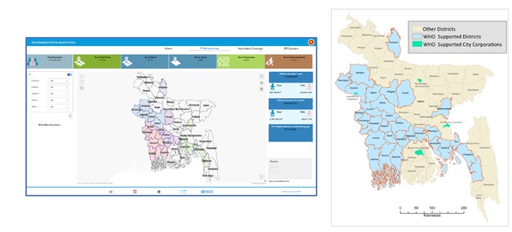
Key Benefits:
• Improved decision making with spatial data analytics;
• Enhanced planning through geographic insights;
• Optimized resources across logistics, vaccines, and workforce;
• Real-time monitoring of immunization gaps and outbreaks;
• Clearer communication through visual data presentation.
By embracing GIS, Bangladesh is setting a new standard in precision public health, driving equity and effectiveness in its immunization program.
------
Authors: Hasanuzzaman Khan Md. - Data Manger, WHO, Bangladesh; Rajendra Bohara - Team Leader-IVD, WHO, Bangladesh.
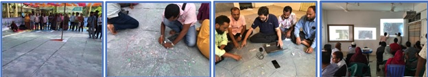
Photo: Health workers developing GIS based micro plan in the field.